| Stanford
Area Trails walk/run/bike/horse |
Executive Summary
In general, the proposed trail route for S-1 is suboptimal but could be made acceptable, while the proposed route for C-1 is totally noncompliant with the letter and spirit of the County Trails Master Plan and General Use Permit. Worse, the applicant is proposing to omit building certain of the segments of trail C-1 along the route they propose for reasons that are specious. The applicant owes the county an easement for trail C-1 about 3.6 miles long and 25 feet wide at a location to be determined. We are not discussing whether there is such an obligation; that is in the General Use Permit accepted and signed by the applicant's officers and the Board of Supervisors of Santa Clara County. We are discussing the details of what property is to be dedicated to recreational use. The applicant's proposed routing would not provide a viable
recreational trail. At best, it would provide a usable bicycle transportation
route. Our detailed commentsGreg Betts, the Palo Alto Open Space manager, is taking the lead on trail S-1, and we generally leave comments on that route to him. His main concerns are that the trail provide a good connection between the intersection of Stanford Avenue and Junipero Serra (where the City of Palo Alto trail system ends) and the Arastadero Preserve of the City of Palo Alto. Regarding trail C-1, we make the following comments: Stanford's proposal for trail C-1 consists mostly of ways to route the trail around Stanford land. The Countywide Trails Master Plan shows a route east of San Francisquito Creek across Stanford land. Stanford's proposed route is west of the creek by as much as half a mile, in San Mateo County, and mostly off Stanford land. Bear in mind that all this is a proposal by the applicant to avoid building along a more desirable, and safer, recreational route that would cross Stanford land east of the Stanford golf course. Our proposed route for the segment north of I-280 goes through the campus along existing pathways, across Junipero Serra at Campus Drive (a signaled intersection), along the eastern perimeter of the Stanford golf course, and exits Stanford property at Piers Land and Alpine Road, connecting to an existing trail at that point. Alternatively, it could go under I-280 at an existing but little-used cattle tunnel and continue through the Felt Lake area to connect to the DeAnza National Trail near Arastadero Road or the Arastadero Preserve of the City of Palo Alto. In this document we're concentrating on the sections north of I-280, which present the most problems. Alpine Road is a road through hilly terrain, and much of the road is cut out of hillsides. This has limited the width of Alpine Road, and as a side effect has severely constricted the paths alongside it as the road has been widened over the decades. Slopes along the road are in the 45 degree range, near the limit of what can be supported without retaining walls. The east side of the road, where Stanford proposes to put the trail, runs alongside the Happy Hollow subdivision. Structures and fences come as close as 17 feet to the edge of the paved highway. The existing trail is basically an asphalt sidewalk, with occasional gaps. The existing Alpine Road trail was built as a horse trail in the 1960s, with federal funding. (Although currently signed as a bike trail, the designation does not seem to have been changed by official action.) Within a half mile of the trail in the segments under discussion are six large horse facilities (Portola Pastures, Creekside Stables, Piers Ranch, Webb Ranch, the Portola Valley Training Center, and the Stanford Equestrian Center.), totaling about 500 horses. The trail sections south of I-280 are routinely used by horses, although heavy traffic north of I-280 has discouraged horse use of that segment. Most bicyclists tend to use the bike lanes on Alpine Road, which, although narrow and dangerous due to heavy traffic, are well-maintained and flat. We take the position that all sections of trail C-1 south of the Palo Alto city line (the urban boundary) should be "shared-use trails, natural tread" as defined in figure G-1 of the Trails Master Plan, which includes off-road bicycle, pedestrian, and equestrian usage. This is a recreational facility, not a sidewalk. Segment-by-segment notes(The segment terminology here follows Stanford's proposal; the County Trails Master Plan uses a different nomenclature.) Segment A - Sand Hill Road from El Camino Real to the Menlo Park border (1.5 miles)Considerable work has been done in this segment as part of the Sand Hill Project, but there are still gaps. Stanford asks that the existing trails (basically sidewalks and bike lanes) be accepted as sufficient. They write "This segment does not conform precisely to the County design guideline. The improvements are less than two years old, provide a variety of safe and comfortable recreation and transportation opportunities for pedestrians and cyclists."
The trails don't conform to County guidelines because the county requires a recreational route, while Stanford built transportation facilities. They also left gaps, dangerous gaps, which have already killed one Stanford student forced to cross busy Sand Hill Road at an uncontrolled point while jogging. We have proposed improvements which would fix those gaps. County staff recognizes this requirement in their Recommendation 2. Segment B - Sand Hill Road from the Menlo Park border to Junipero Serra (0.27mi)This is a narrow section of roadway which Stanford wants widened from two to four lanes. However, the City Council of Menlo Park has addressed that issue and voted not to widen the road. The applicant proposes to make their compliance with the GUP conditional on the City of Menlo Park reversing their decision. The applicant is thus asking first that they not be required to route the trails through the campus (which is a viable alternative and identified as such by county staff) and second, having requested a reroute for the applicant's convenience, not to actually build the rerouted segment. This is unacceptable and noncompliant.
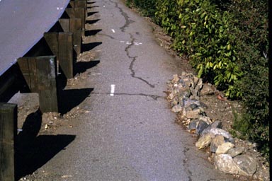
County staff recognizes this requirement in their Recommendation 2. Segment C - Sand Hill/Santa Cruz intersection to Alpine Road alongside the Stanford Golf Course (0.25 mi.)This is currently a viable section of trail, separated from traffic for most of its length by a barrier of trees and shrubbery. Unfortunately, it doesn't connect to much, so it is underutilized. It is also substandard according to current trail standards, but improvement is quite possible. The current trail easement does not conform to the County minimum of 25', but there is sufficient room for an expansion. Because the current easement is undersized, a retaining wall was built to support Alpine Road. The trail lies below the retaining wall. Similar construction would be required along other segments.
Segment D - This is a continuation of segment C above, continuing
along the Stanford Golf Course to Rural (?Stowe) lane.
|
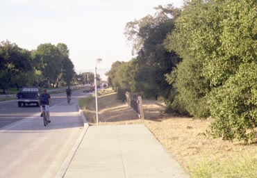
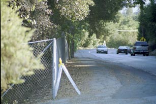 |
Existing Alpine Road "trail" alongside Stanford property. The existing trail is unsafe and too close to the road, but space exists for widening. Segment D. |
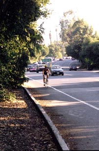
Segment E - Happy Hollow (0.65 miles)
This segment runs along the frontage of a subdivision, not the applicant's property. But because this is a proposed substitution by the applicant, the applicant has the burden of acquiring the necessary easements from property owners in the area.
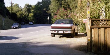 |
Stanford's proposed site of 25' trail easement. That parking space and fence will have to go, along with part of the homeowner's front yard, to put a trail through there. Looking north at 2443 Alpine Road in the Happy Hollow area, segment E. |
This section of Alpine Road is cut out of the side of several hills and will present construction problems. Alpine Road is currently about as wide as it can get without using retaining walls to hold up the hills. This has squeezed down the pedestrian paths (which are too narrow to qualify as proper sidewalks, let alone recreational trails) to a one-person width.
One section of the Alpine Road trail in the Stowe Lane area is the subject of current litigation. Some of the houses in that section appear to be built on a County easement, and fences have been placed on land undisputedly owned by the County. In this section, the terrain drops off sharply at the edge of Alpine Road, drops about 30-40 feet at a slope of 45-50 degrees, and then becomes flat. Development has progressed to the bottom edge of the slope, which is roughly the edge of the disputed easement. The disputed section is the steep slope. Even if the legal problem can be resolved, trail construction would require substantial cuts and retaining walls. The required 25' trail setback from occupied residences in an urban service area could not be met without acquisition and demolition of several houses.
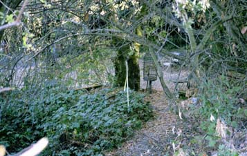 |
We're peering
over a fence from Alpine Road into someone's back yard. See
that white stake next to the bird cage? The County of San Mateo
has an easement down to that point, and that's the easement
Stanford wants to use. The property owners are litigating with
San Mateo County over this land.
It's about a 20' drop with a 45 degree slope down that hill. The trail would have to be cut into the side of the hill, with a retaining wall to hold up Alpine Road. And that would still put a trail in someone's back yard. In Segment E. |
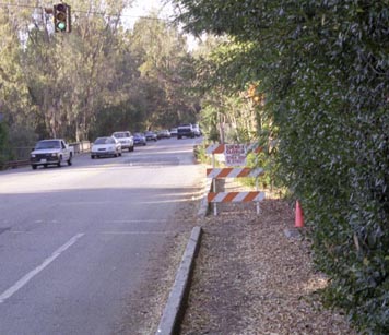
The section of Alpine Road bordered by a vehicle guardrail presents serious problems. The existing "trail" in that area is just the pavement fringe extending beyond the guardrail, is 5 to 6 feet wide, and is bordered by a 45 degree drop-off and vegetation. Beyond the vegetation is a private road and developed private property. The County does not have an easement beyond the road edge in this section.
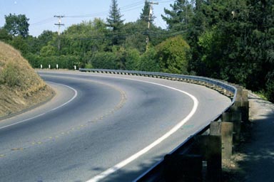 |
That guardrail is there for a reason; the slope of the land was too steep for a road shoulder. Note minimal "trail" to right of guardrail. This photo was taken on a quiet Sunday afternoon. On weekdays, this road is jammed with traffic from I-280 to the Stanford campus area. Looking north on Alpine Road, in Segment E.
|
 |
The existing "trail" behind the guardrail. This barely qualifies as a sidewalk, let alone a recreational trail. It's about a 10' drop with a 45 degree slope down that hill on the right. The owners of the adjacent land have planted shrubs to screen their property from the road. There are houses behind that shrubbery. Looking north on Alpine Road, in Segment E. |
The affected landowners have not been contacted by the applicant, Santa Clara County, or San Mateo County. The ones we've talked to hate the idea of a trail running through their back yards.
County staff recognizes many of these problems in their Recommendations 2 and 3.
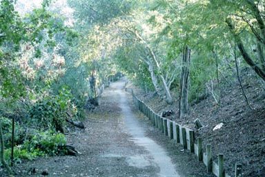
Segment F - Piers Lane to Arastadero Road via Alpine Road (2.1 miles)
This is several miles of trail, and exists but does not meet current standards. Most of this section is in the Town of Portola Valley. The Town of Portola Valley has an active trail dedication and management program, run by the Portola Valley Trail Commission and the Town Engineer. The Town has not been consulted in this matter by the applicant.Our contacts with the Portola Valley Trail Commission, before which we have appeared formally, indicate that their plans for buildout of trail C-1 call for a trail through the Felt Lake area on Stanford land, and Portola Valley would insist on this should the applicant come before the Town in a matter affecting that property. Comments on this long segment will be developed further after consultation with Portola Valley officials.
County staff recognizes the lack of coordination with Portola Valley in their Recommendation 5.
Operational and implementation issues
The applicant suggests a "phased implementation". Early drafts of the General Use Permit, drafted by the applicant, requested a phased implementation of trails based on development thresholds. That language was not accepted by the County and does not appear in the final GUP. Thus, a phased implementation is inappropriate. That issue was disposed of during the GUP negotiation process.
The applicant states "We may wish to operate this trail similarly to the Stanford dish trails and use the personnel and management structures currently in place for this purpose." As regards maintenance, this is a subject for negotiation between the landowners, the applicant, and the County. (Recall that the applicant is proposing trails over the lands of others.) As regards patrols and enforcement, section M -5.0 of the County Trails Master Plan calls for patrol and ranger operations to be performed by County personnel. The landowner may not exert control of a public dedicated trail easement, any more than they may exert control over a public highway.
As section M - 5.7 suggests, the Midpeninsula Open Space District is an appropriate agency to take on this function under contract, especially since MROSD has personnel in the North County.
Source documents
These are the official documents filed with the County of Santa Clara.
- The County's response (19 September
2001)
(Note: These files were generated by scanning paper documents and may contain scanning errors.)